Map of the target areas of the project
SupMed aims to improve farmers resilience from Baalbeck-Hermel Region (Lebanon) and Luxor (Egypt) against climate change effects by reducing their dependance on water resources.
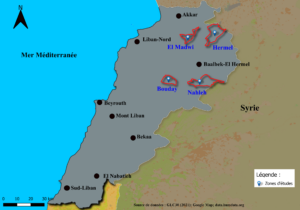
The SupMed target areas in Lebanon
Three areas have been identified in the Governorate of Baalbeck-Hermel
- The village of Bouday: located at 15km from the North-West of the Bekaa valley, to the West Litanie river and at the bottom of Mount Lebanon. There are 753 farmers on an agricultural area of 23198 ha, the production is mainly composed of wheat, vegetables and tobacco. It has a continental climate with an average of rainfall of 600 mm.
- The village of Nahleh: located at 6 km on the North-East of Baalbeck city (on the Anti-Lebanon side). The climate of this area is continental, with an average of rainfall of 400mm in winter and a dry hot summer. There are 269 farmers who produce fruit such as apricots, cherries and almonds. The total agricultural area is 7578 ha with 95% of arboricultural crops.
- The village of Hermel-El Mudwy: located at the North of the Bekaa valley. The climate is dry (200mm of rainfall on average) dominated by olive cultivation and mainly irrigated annual crops (wheat, vegetables, tobacco, fodder). There are 4719 farmers on an agricultural area of 9200 ha.
